
Long-term Research Projects
Long-term Research and Monitoring Projects at CPBS
Cano Palma runs several long-term monitoring projects that seek to better understand and document the local flora and fauna.
Caiman Census
Spectacled caiman (Caiman crocodilus) are a common sight around Caño Palma. Sometimes called the common or brown caiman, they are part of the Alligatoridae family, and can be found throughout their native range in Central and South America and the Caribbean. They can also be found in Florida, Cuba, and Puerto Rico, where they were introduced. Spectacled caiman are considered low risk according to the IUCN Red List of Threatened Species.
Caiman are smaller than most crocodiles or alligators, with males growing up to 2 metres (6.5 feet) in length, and females reaching 1.4 metres (4.5 feet) in length. They can live between 20 and 40 years. Found primarily in freshwater wetland habitats, they typically prefer slow-moving water. Though they can be found in both deep and shallow water, they only require enough water to submerge their bodies. These caiman tend to be solitary outside the mating season. Individual home ranges are small and are typically inhabited year-round. Caiman are considered generalists and opportunistic feeders, a fact that is often thought to aid their ecological success.
CPBS began surveying for caiman in 2009, with consistent weekly censuses beginning in 2012. The purpose of this study is to gather baseline data on the spectacled caiman, including distribution, age, and abundance in the Caño Palma. Improving our understanding of the status of the local caiman population can provide insight on the health of the ecosystem as a whole.
Surveys occur once a week after sunset. Surveyors use flightlights to shine light into the area where the waters edge meets the land. Caiman eyes glow orange when they are hit by light, and surveying this way is a simple method to detect caiman with low impact to the species. Upon detection, the age class of the caiman is determined, the location (GPS) is taken, and the survey continues. This method has allowed us to create a long-term dataset detailing the local caiman population.
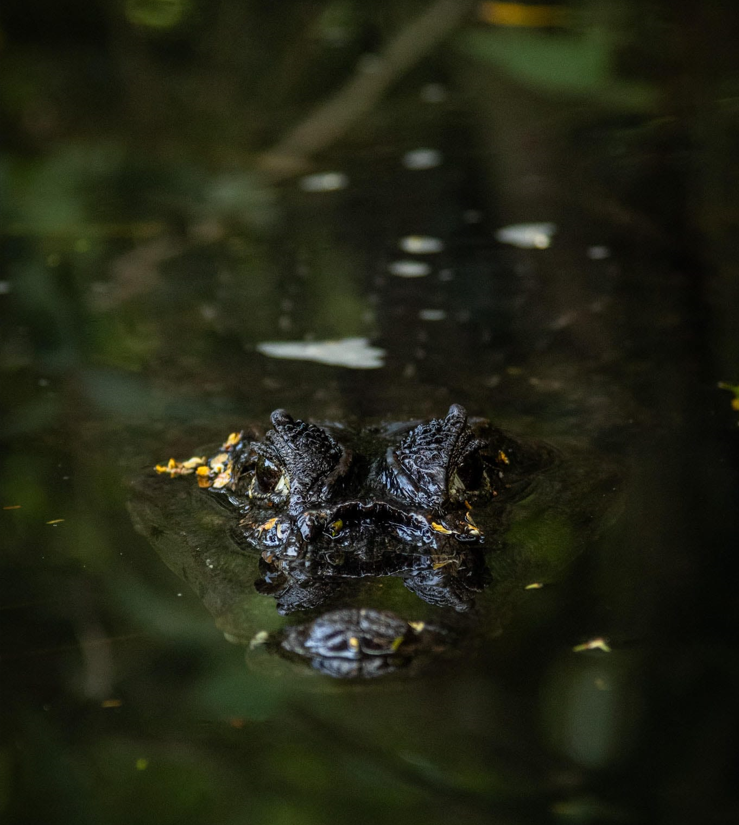
© Samuel Duditlieux, @sam_outdoor_photography

Great Green Macaw Abundance Surveys
The great green macaw (Ara ambiguous) is a large, green parrot known for its loud and consistent calls. These macaws typically live in humid and wet Neotropical lowlands and foothills, but can be found on edge habitats and will cross large open areas. They have a strong preference for Dipteryx panamensis (common name: almendro, mountain almendro), but will also feed from Terminalia catappa (common name: beach almond). These macaws are very social, with family groups of 5-6 individuals and foraging and roosting groups of up to 50.
With an estimated 500-1,000 individuals left in the wild, a number believed to be decreasing, great green macaws are classified as critically endangered by the IUCN Red List of Threatened Species. Their biggest threats are the destruction of habitat for human development, particularly logging for agriculture, and removal from the wild for the pet trade.
Great green macaws have been observed in the CPBS area since 2013, when previously sporadic events began to become a common occurrence, providing evidence of the formation of a local population. It is thought that local almendro trees could be a driving factor in the recent influx of these birds to the area.
CPBS began officially surveying the great green macaw in 2017 with the purpose of determining the local abundance in Tortuguero to monitor the population over time, and to identify local movement patterns. Surveys take place once weekly (one morning and one evening for each survey day) at one of five locations along the Caño Palma, in San Francisco, and Tortuguero. When detected, surveyors record the location of the macaw(s), the number of individuals, their behaviour, and the direction in which they travel from/to. If scarlet macaw (Ara macao) are present, the same information is recorded as an incidental occurrence.

© Samuel Duditlieux, @sam_outdoor_photography

Large Mammal Monitoring Program
The Large Mammal Monitoring Program began to take form in 2007, and has been consistently running since 2012. The program aims to estimate community composition and species richness in the area and evaluate habitat associations of resident species. The impact of anthropogenic changes in the community, including increased tourism, is also analyzed. By developing and maintaining a long-term dataset on the presence and abundance of local mammals, we are better equipped to understand changes to the population, potential threats, and possible solutions.
Three forest transects were established across the survey area, each of which includes unique ecosystem services/environments for local mammals. This allows us to survey across a diversity of systems that may support different species. Each transect is surveyed once weekly to record evidence of mammals. Evidence includes not only direct sightings, but tracks, trails, feces, foraging evidence, and nests. By alternating between morning and evening surveys, surveys take place when we are most likely to encounter individuals.
Since the development of the Large Mammal Monitoring Program, multiple papers have been published using the data collected.

Jaguar caught on camera traps
Three-toed sloth by © Samuel Duditlieux, @sam_outdoor_photography

Marine Turtle Monitoring & Tagging Program
Since 2004, the marine-turtle monitoring and tagging program has been a major focus for CPBS. Conducted between March and November each year, this program was designed to conduct research on nesting sea turtles, to monitor their health, to educate the public on sea-turtle ecology and conservation, and to deter poaching through a consistent presence on the beach.
The program consists of two daily surveys: one (or more) overnight survey and one morning survey. Night surveys are designed so surveyors have the best opportunity to encounter nesting sea turtles. The 5km (3 mile) beach transect is walked throughout the night by one or more teams. If there are multiple teams, times are staggered to increase the probability of detection, particularly at the height of turtle nesting season. When teams find a sea turtle, they collect data on her, including an egg count, body measurements, and body check. If she is not tagged, the team will tag her, giving her a unique identification number. The location of the nest is then taken, and the team stays with her until nesting is complete and she safely returns to the sea. Morning surveys are designed to allow surveyors to record additional turtle activity that was not detected by the night teams. They also collect data on any poaching or predation of nests, place mesh where appropriate to protect from predation, and excavate nests following their hatching period to determine nest success. This program has helped protect and conserve sea turtles since 2004 and supported many publications.

Sea turtle hatchling by © Yair Ben-Yacov

Mile 5 of Playa Norte Sea Turtle Surveys
Neotropical River Otter Habitat Use and Distribution Surveys
Neotropical river otters (Lontra longicaudis) are a short, thick-looking otter species, with grayish-brown fur, a long, thick tail, and short legs. They generally weigh around 12 kilograms, and can grow up to 36 cm to 66 cm long. They are found throughout Central and South America, from Mexico to Argentina. They occur in all regions throughout the Neotropics that have available food resources, including rivers, streams, and lagoons, that have plenty of riparian vegetation.
These otters use various shelters within their habitat, including underneath tree roots and inside caves. They communicate by means of scent marking, primarily done through depositing feces - a great way to know if you are in otter territory. They are opportunistic feeders that eat mainly fish and other aquatic species, but they have also been known to eat insects, reptiles, and even small mammals.
An understudied species, they were listed as data deficient on the IUCN Red List of Threatened Species until 2015 when they were listed as near threatened. In some areas the population is at more severe risk of local extinction, and in Mexico, Venezuela, Colombia, Belize, and Ecuador they have been listed as threatened on several national and regional lists. Their biggest threats are human presence and environmental quality. Additionally, conflict with fishermen is a cause of decline, as well as mining activities, pollution, cattle ranching, urban expansion, and hydroelectric works.

Otter surveys by © Yair Ben-Yacov

Plant Phenology
Phenology is the study of cyclic and seasonal natural events, most often focusing on how these respond to climate change. The plant phenology survey at CPBS project began in 2007 and has been consistently performed every month since 2013. Performed within the first 10 days of each month, the survey is designed to collect data on the tree species in the CPBS area. Our goal is to gain a better understanding of these tree species by identifying phenophases and comparing phenophase patterns across different habitats (forest and canal) for each species.
The survey takes place in two transects: one in the forest and along the canal. 160 trees are labeled along each transect and are inspected during every survey. Surveyors examine each marked tree to determine the phenophase the tree is experiencing (fruiting, flowering, producing new leaves, or dropping leaves), as well as what percentage of the tree is in that phase. Trees can experience more than one phenophase at a time. By building our long-term database of plant phenology around CPBS, we are better able to identify natural patterns as well as the potential impacts of climate change.

A tree marked for phenology surveys
Snake Ecology & Morphology
The forests surrounding CPBS support a variety of snake species. Our weekly surveys allow us to examine the species composition in the area adding to our long-term database. Three transects have been set up around the Tortuguero area, one of which is surveyed each week. Surveys are performed at night as snakes are primarily nocturnal and our survey methods, using flashlights to catch reflections in snakes eyes, are more successful after dark. When surveyors find a snake, they are captured and brought back to the station to allow us to collect data on them in a safe environment for both the snakes and the handlers. The location of the snake is recorded and, following processing, the snake is returned to this exact location. The data collected on snakes includes species, age, sex, and body measurements.
In 2014, this project was expanded to allow PIT tagging of snakes. PIT tags (Passive Integrated Transponders) are small tracking devices (about the size of a grain of rice) that are inserted under the skin of an animal and allow researchers to assign them an individualized serial number. PIT tags are commonly used in wildlife research and do not harm the individuals. By using PIT tags, researchers can track animals in a minimally invasive way for their entire lives. The ability to track and recognize individuals over space and time adds an important aspect to wildlife research and conservation that would not be possible without these devices.

© Ralf Verkleij

Tent-making Bat Ecology
Tent-making bats are species of bat that, rather than seeking out natural shelters, chew the leaves of plants in a way that creates ‘tents’. Different species modify the leaves in different ways, with some bending large leaves into an inverted ‘V’ shape, and others bending multiple leaves to create an unopened umbrella-shaped shelter. These tents are used as protection from rain and predators, and often a single group of bats will have multiple shelters they use at any given time.
Tent-making bat species at CPBS include the Honduran white bat(Ectophylla alba), the Common tent-making bat (Uroderma Bilobatum), Thomas fruit-eating bat (Artibeus watsoni), Jamaican fruit bat (Artibeus jamaicensis), Northern little yellow-eared bat (Vampyressa thyone)
In 2015, a concrete tourist path was installed in one of the forests neighboring CPBS. To understand the impacts of this path on tent-making bats, CPBS performed tent-making bat surveys prior to its installation, during its installation, and continues these surveys today. This study was designed to understand how the installation of the path and the increase in tourism and foot traffic in the forest affected these species. In 2017, the survey was expanded to the Archie Carr Wildlife Refuge to increase our database.
To conduct tent-making bat surveys, surveyors walk a transect and look for both known tents and new tents. Tents will be inspected to determine the species of bat using the tent (as determined by the type of tent) and whether the tent is active. While finding individual bats in tents is the most reliable method of determining activity, other signs include guano and remnants of food beneath the tent. If guano and/or food remains are found beneath a tent, they are removed to allow the researchers to better determine activity upon the next visit. Once a tent is detected, it will be revisited during each survey until it is confirmed to be abandoned, as determined by a prolonged period of time with no signs of use.

© John Rowland

Climate Data Collection
Climate data is collected twice a day on base at CPBS. Data collected includes temperature, humidity, river depth, colour, and direction, rainfall and cloud cover. The data collected is integrated into many other projects, including as variables when analyzing long-term monitoring projects and student projects.
Forest Plot Monitoring
The Neotropical region (including areas of Central America, the Caribbean, and South America) is highly diverse geographically, climactically, and biologically. The Neotropics are a zoogeographical or phytogeographical region and one of the six major biogeographic areas of the world. Neotropical rainforests specifically are classified as lowland forests with mean annual precipitation greater than 1.8 metres per year, high mean annual temperatures above 18 degrees Celsius, and less than 7 degrees Celsius in seasonal temperature variance. These forests are known to host exceptional levels of biodiversity. However, they are often understudied. As these ecosystems are impacted by a multitude of stress factors, including climate change, upstream agriculture, local and national socio-economics, and broad anthropogenic actions, it is vital that we understand their natural state as well as any changes to that state in order to conserve them.
In order to address this at CPBS and to further understand the diversity of lowland, palm dominated wet forests in the CPBS area, we set up comparative 1 hectare forest plots. These plots were developed based on modified Smithsonian methodology. The annual survey takes place during January and February.
